County Carlow
“CAH-har-lakh” · four lakes, from ceathair (four) + loch (lake)
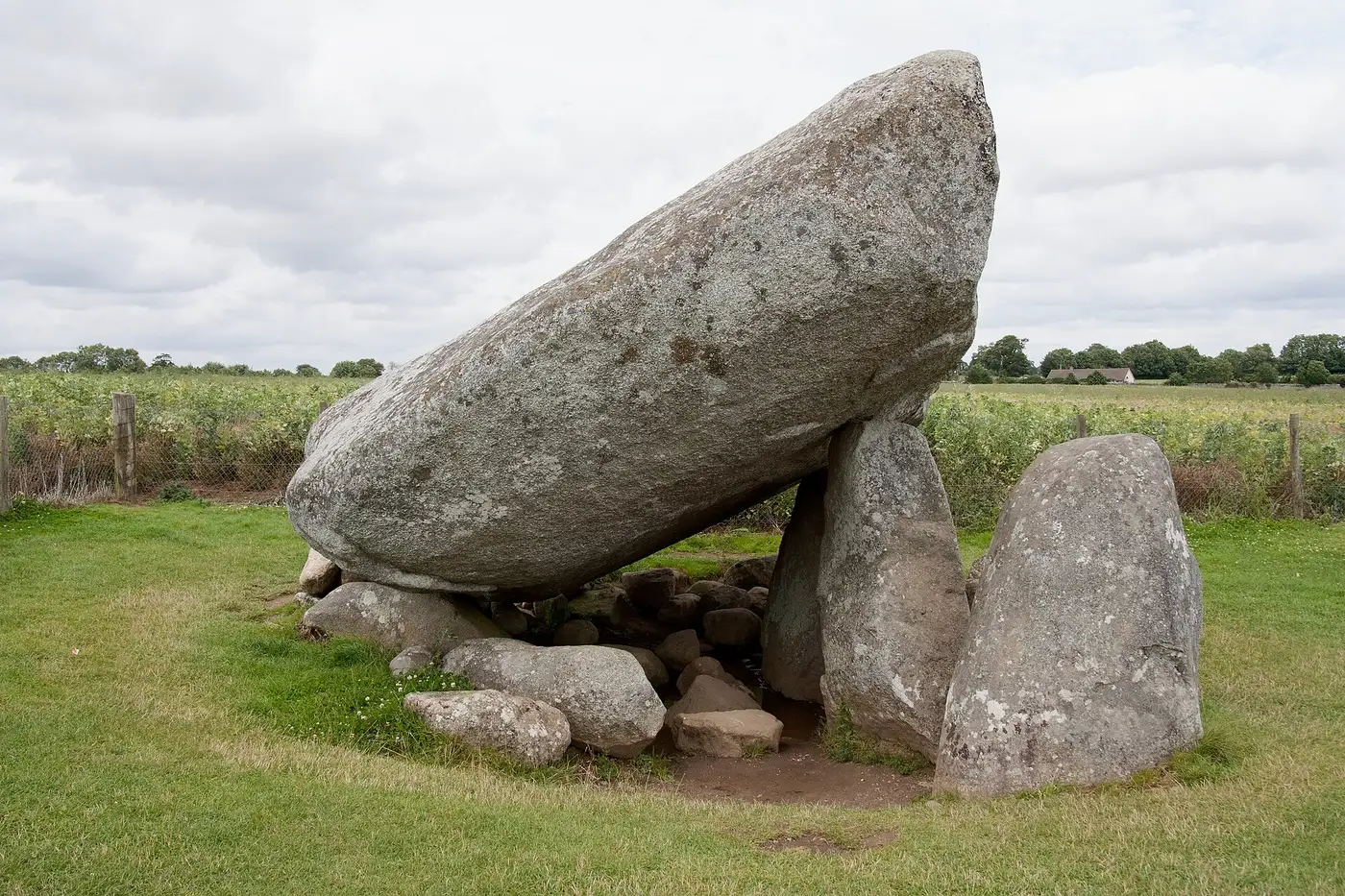
Known as The Dolmen County. For Browneshill dolmen outside Carlow town, whose capstone weighs an estimated 150 tonnes and is believed to be the heaviest in Europe. How Neolithic farmers raised it is still an open question.
A fact like this for every county and every age →
Compare with another county → · Printable one-page summary →
Carlow has perhaps the densest scatter of megalithic monuments in Ireland — standing stones, bullauns, cairns and dolmens, which give it the name the Dolmen County; the Brownshill Dolmen is reputed to be the largest in Europe. Holding both the navigable Barrow and the Slighe Cualann, one of the great roads to Tara, the area was vital to anyone who wanted to be king of Leinster, and by the 11th century the Mac Murchada branch of the Uí Ceinnselaig held that kingship.
The Normans founded the borough of Carlow in 1210, and the Liberty of Carlow of 1247 was more than three times the size of today's county, reaching the coast at Arklow. Art MacMurrough-Kavanagh, king of Leinster, came to control more than half of it, and took payments from the colonists that amounted to rent for his sovereignty; his descendants still live at Borris House. From 1361 to 1374 Carlow was the capital of the English lordship of Ireland. The land on its fringes that fell to the O'Byrnes and others went to Wicklow in 1606, which is why today's boundary follows the old Norman core.
After Cromwell, Carlow was one of four counties set aside to pay the Commonwealth's debts, though much of that land went back to its owners at the Restoration. In 1798 the rising in Carlow was crushed at the Battle of Carlow in May, followed by months of reprisals; Irish was still spoken in the county into the 1870s. In the War of Independence the Carlow Brigade based itself at Duckett's Grove, and the Carlow Republican District Court of February 1922 was the first court held under the new Free State. W. T. Cosgrave, first head of an independent Irish government, sat for Carlow–Kilkenny from 1921 to 1927.
Drawn from the History section of the Wikipedia article on County Carlow ↗, rewritten here and adding nothing it does not say; licensed CC BY-SA 4.0. The chronology above is this site's own; where the two differ, the article is the one to check.
Carlow is the second-smallest of Ireland's 32 counties by area, and the third-smallest in terms of population. It is the second-smallest of Leinster's 12 counties in both size and population. Carlow is landlocked and bordered by five counties – Kilkenny to the west, Wicklow to the east, Wexford to the southeast, and Laois and Kildare to the north. Carlow town is both the county town and largest settlement, and is situated on the River Barrow in the north of the county approximately from Waterford and from Dublin.
Read the full article ↗ · Text from Wikipedia, licensed CC BY-SA 4.0.
Tap a name for its full page — story, homeland map and neighbours. Or see all surnames from County Carlow, with the other counties each name is tied to.
Towns. Carlow Ceatharlach (27,351, 2022), Tullow An Tulach (5,138, 2022), Bagenalstown Muine Bheag, Leighlinbridge Leithghlinn an Droichid. What every town name means →
Legends set here. St Mullin’s — the death of Mad Sweeney. On the atlas →
First names that belong here. Art, Criomhthann, Lasairian.
At the 2022 census, 21,426 people in Carlow said they could speak Irish. 464 speak it every day outside school, and 1,179 weekly.
1 primary school here teaches entirely through Irish (2025/26, 432 pupils), and 1 secondary school.
CSO, Census 2022, table SAP2022T3T2CTY. Every county compared →
Mount Leinster (Stua Laighean), 794 metres, in the Blackstairs Mountains, on the county boundary and shared with a neighbouring county.
Rivers and loughs: River Barrow, River Slaney.
MountainViews, via Wikipedia. Every county's highest point → · Rivers and loughs →
Hurling: no senior title.
Football: no senior title.
-
John Tyndall ↗
· 1820–1893
Irish physicist -
Nicholas Aylward Vigors ↗
· 1785–1840
Irish zoologist and politician -
William Desmond Taylor ↗
· 1872–1922
Irish-American film director and actor, born at Carlow -
Finnian of Clonard ↗
Irish saint, born at Myshall -
Pierce Butler ↗
· 1744–1822
United States Founding Father, from South Carolina -
Patrick Francis Moran ↗
· 1830–1911
Catholic cardinal, born at Leighlinbridge -
Yvonne Barr ↗
· 1932–2016
Irish virologist, born at Carlow -
Thomas M. Patterson ↗
· 1839–1916
Union United States Army soldier -
Charles K. Gerrard ↗
· 1883–1969
Irish actor, born at Carlow -
Tom Nolan ↗
· 1921–1992
Irish politician, born at Myshall -
Myles Keogh ↗
· 1840–1876
Union United States Army officer, born at Leighlinbridge -
Samuel Haughton ↗
· 1821–1897
Irish scientific writer, born at Carlow -
Pádraig Ó Snodaigh ↗
Irish activist, born at Carlow -
William Dargan ↗
· 1799–1867
Irish railway engineer -
Joy Tivy ↗
· 1924–1995
Scottish geographer, born at Carlow -
William Baillie ↗
· 1723–1810
Irish artist, printmaker and art collector -
Frederick Keppel ↗
· 1845–1912
Art dealer, born at Tullow -
Michael Farrell ↗
· 1899–1962
Irish author, born at Carlow -
James Lennon ↗
Irish politician, born at Borris -
Laurence Ryan ↗
· 1931–2003
Irish priest, born at St Mullin's -
Michael N. Nolan ↗
· 1833–1905
Irish-born American congressman for New York -
Arthur Matthew Weld Downing ↗
· 1850–1917
British astronomer, born at Carlow -
John O'Byrne ↗
· 1884–1954
Irish barrister, Attorney General and judge, born at Carlow -
Eamonn Kinsella ↗
· 1932–1991
Irish athlete, born at Carlow -
Thomas P. O'Neill ↗
· 1921–1996
Irish scholar, born at Ballon -
Henry Bruen ↗
· 1856–1927
Irish cricketer and army officer, born at Oak Park, County Carlow -
Patrick Teehan ↗
· 1904–1985
Irish politician, born at St Mullin's -
Peter F. Collier ↗
American publisher, born at Myshall -
Robert Francis Ruttledge ↗
· 1899–2002
Irish ornithologist, also known as "The Major" -
Michael Keogh ↗
· 1891–1964
Irish soldier, born at Tullow
From Wikidata: people whose recorded birthplace is in the county, who have a Wikipedia article and are no longer living, with dates shown only where the article confirms them, ordered by how many languages Wikipedia covers them in. Traditional birthplaces of early saints are as Wikidata records them. Dates are left off where the sources disagree.
Carlow had 86,228 people in 1841 and has 61,931 now (-28%). Its peak was 86,228 in 1841; its low point 33,342 in 1961, -61% of 1841. It has never regained the population it had before the Famine.
| 1821 | 1831 | 1841 | 1851 | 1861 | 1871 | 1881 | 1891 | 1901 | 1911 | 1926 | 1936 | 1946 | 1951 | 1956 | 1961 | 1966 | 1971 | 1979 | 1981 | 1986 | 1991 | 1996 | 2002 | 2006 | 2011 | 2016 | 2022 |
|---|---|---|---|---|---|---|---|---|---|---|---|---|---|---|---|---|---|---|---|---|---|---|---|---|---|---|---|
| 78,952 | 81,988 | 86,228 | 68,078 | 57,137 | 51,650 | 46,568 | 40,936 | 37,748 | 36,252 | 34,476 | 34,452 | 34,081 | 34,162 | 33,888 | 33,342 | 33,593 | 34,237 | 38,668 | 39,820 | 40,988 | 40,942 | 41,616 | 46,014 | 50,349 | 54,612 | 56,932 | 61,968 |
Census returns as tabulated in the county's Wikipedia article. All 32 counties, 1821 to today →
- Brownshill dolmen · dolmen
- Lorum High Cross · high cross
- Nurney Cross · high cross
- St Mullin's · round tower · incomplete · 1 m
- 9 castles · Ballyloughan Castle, Ballymoon Castle, Carlow Castle, Castlemore Moat, Clogrennane Castle and more
Every pin is placed by its documented coordinates. All the monuments of Ireland →
Everything on the site about County Carlow
The county
History
Monuments and heritage
Coast and country
People and culture
What is the Irish name for County Carlow?
Ceatharlach. Carlow is one of the 12 counties of Leinster (Cúige Laighean).
Who ruled County Carlow in the Middle Ages?
Around 1014 it was held by Kingdom of Leinster (Mac Murrough); by 1450, MacMurrough Kavanagh. The full era-by-era chronology is on this page.
What surnames come from County Carlow?
Names historically associated with Carlow include Brophy, Kavanagh, Kinsella, Lynam, Nolan, Wall.
What does Ceatharlach mean?
Ceatharlach, said “CAH-har-lakh”, means four lakes — from ceathair (four) + loch (lake). Traditionally read as four lakes, though there are none there now and the reading is not certain.
What is the population of County Carlow?
61,931 at the 2022 census, against 86,228 in 1841, before the Famine.
What is the county town of Carlow?
Carlow. County Carlow covers about 897 km², which makes it the 31st largest of the 32 counties.
Who are famous people from County Carlow?
Among the best-known people born in Carlow are John Tyndall, Nicholas Aylward Vigors, William Desmond Taylor, Finnian of Clonard, Pierce Butler, Patrick Francis Moran. The full list, with their birthplaces, is on this page.
What did the Famine do to County Carlow?
The census counted 86,228 people in Carlow in 1841 and 68,000 in 1851 (the 1851 figure is approximate): a change of -21% in ten years, through death and emigration.
A clean copy for school projects or the family file; collapsed sections print in full.
- Wikipedia — County Carlow ↗
- CSO — Census of Population 2022 ↗
- NISRA — Census 2021 ↗
- Wikipedia — List of Irish counties by population ↗
- 1841 census of Ireland (county table) ↗
- Historical population of Ireland (county series) ↗
- Logainm.ie — the State's Placenames Database of Ireland ↗
- Wikipedia — Counties of Ireland ↗
- Wikipedia — the county articles ↗
- Woulfe, Irish Names and Surnames (1923), for the surnames ↗
The chronology of who held the county is this site's own reading of the standard histories onto today's county borders, and says so where the fit is rough. Quoted passages are marked and licensed. Spotted an error? Say so — corrections are credited.
- 1911 Census — Carlow ↗
- 1901 Census — Carlow ↗
- Griffith's Valuation — search Carlow ↗
- Down Survey maps — Carlow ↗
- Schools' Folklore Collection — Carlow ↗
- Placenames of Carlow (Logainm) ↗
Free, from the holding institutions. How to begin: the six-step guide → · Spotted an error on this page? Suggest a correction.